How to Report (AND READ) complex science stories. . . .

From Andrew Revkin’s NYTimes environment blog —

http://dotearth.blogs.nytimes.com/2010/01/13/climate-whiplash-in-the-greenhouse/

Kenneth Caldeira, a climate researcher for the Carnegie Institution and Stanford University, criticized a British newspaper article — “Climate change experts clash over sea-rise ‘apocalypse’” — for overplaying the momentousness of one paper projecting a calamitous rise in seas by 2100 and then overplaying the level of dispute over the finding based on new work. Double whiplash, in a way.

Dr. Caldeira wrote:

“I think this story in the Times is indicative of the press’s tendency to make a big story out of every individual paper, rather than reporting the picture that emerges out of the findings of a field of science over time.”

He went on to discuss how the original paper’s sea-rise projection was, in his view, flawed, but also how the way it was described distracted from overall confidence about rising seas in a warming world. Then he wrapped his thoughts up this way:

“I think science journalism is in a terrible spot right now. Most scientific stories unfurl slowly, in a process that involves many different published papers, but journalists are tied to the news cycle and need to make a news event out of each story. So, to get space in the newspaper, they need to make it seem as if each published paper is a major event and the science is being whiplashed back and forth by each published study. (This is supported by the scientists who do each study and naturally feel the importance of their own study.) As a result, the public gets an exaggerated view of the volatility of scientific understanding. If the journalist[s] do not overemphasize the importance of individual studies, the stories will not get in the paper, and stories on the rising seas will be nowhere in the newspaper. Where is there a place for journalism that focuses on long-term trends?”

Check Revkin’s original piece (and monitor the blog over time) for more elucidation on the science of climate change impacts. 
Posted in Uncategorized | Leave a comment

Preliminary GIS links from the Caribbean GIS blog by Vijay —

at the url — http://caribbean-gis.blogspot.com/2010/01/earthquake-in-haiti-via-georss-feed.html

Geographic Information Systems/ Science (GIS), and its application in and around the Caribbean.

Wednesday, January 13, 2010

Earthquake in Haiti via GeoRSS feed

Media_http2bpblogspot_dpmdb

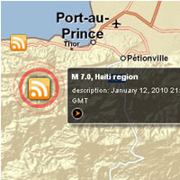
The scale of the humanitarian crisis caused by the earthquake in Haiti is now beginning to be understood. One source of information is the new GEOSS Viewer. Its use of up-to-date data, via RSS feeds, and its smooth interface makes it an excellent visualisation tool for both GIS Specialists and wider users such as the news media. It is a website that allows for the search of data across multiple data portals and has analytical capabilities, such as population estimations. It is currently focused on the disaster area of Haiti. There is a GeoRSS feed that will show the locations of the earthquakes there – from the USGS Earthquake data. The site is being enhanced with additional data and imagery to support humanitarian response operations.

The site is built using the ArcGIS Server API for Flex Sample Viewer, which is a free API for non-commercial use – which any organization can download and use from here:http://resources.esri.com/arcgisserver/apis/flex/. Additional widgets are available from the code gallery here:http://resources.esri.com/arcgisserver/apis/flex/index.cfm?fa=codeGallery.
Thanks to Carmelle Terborgh for the details.

Posted in Uncategorized | Leave a comment

Bring Sunlight to Annapolis. . . .

Sunlight in the Year Ahead
For almost four years, the Sunlight Foundation has used cutting-edge technology and ideas to make government more transparent and accountable.

Now, to really take things to the next level we are going to be launching a nationwide campaign for greater government transparency – from city councils to Capitol Hill – and we can’t do it without you.

One thing that we know for sure is that we won’t get much of anywhere without your skills, your best ideas, your political action and your leadership to bring this campaign to life.

Would you be willing to learn more about how you can help? If so, let us know who you are, and we’ll be in touch shortly.

go to the URL below for details. . . .

http://sunlightfoundation.com/campaign/

Posted in Uncategorized | Leave a comment

Mobile Technology Tools . . . .

Recommended —

Ken Banks blog on KWANJA.NET, a developer of mobile technology tools for development 

About kiwanja.net

Kiwanjabanner

Since 2003, kiwanja.net has been helping empower local, national and international non-profit organisations to make better use of information and communications technology in their work. Specialising in the application of mobile technology, it provides a wide range of ICT-related services drawing on over 25 years experience of its founder, Ken Banks. Non-profits in over fifty countries have so far benefited from a range of kiwanja initiatives, including FrontlineSMS and nGOmobile

For full details on kiwanja’s activities, along with links to guest articles and interviews, a database of social mobile applications around the world, latest news and a library of mobile images, visit the kiwanja.net website

Welcome to kiwanja.net!

Posted in Uncategorized | Leave a comment

Climate Change and Environmental Impacts on Coastal Communities


Inquiry into Climate Change and Environmental Impacts on Coastal Communities

This report by an Australian House of Representatives committee on climate change spells out policy options available to coastal communities in addressing sea level rise: protect, redesign, rebuild, elevate, relocate, or retreat.  The report describes the uncertainties local planning councils will face in deciding which policy would apply best in each circumstance.  Individual chapters may be downloaded for convenience.

http://www.aph.gov.au/house/committee/ccwea/coastalzone/report.htm

Posted in Uncategorized | Leave a comment

St. Thomas National Historic Site (1960-1975)

Happy New Year.. . . 

Michael O’Neal, Senior Associate of Island Resources, and the former president of H. Lavity Stoutt Community College in Tortola, found this fascinating little squib from the National Parks Traveler blog:

Pruning the Parks: St. Thomas National Historic Site (1960-1975) Left the Park System as Quietly as It Entered

Posted December 24th, 2009 by Bob Janiskee

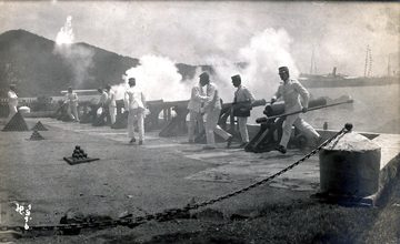
Upper photo:Danish soldiers fire salute from the fort’s Salute Battery as U.S. representatives come ashore at Kings Wharf on March 31, 1917, for transfer of ownership ceremonies. St. Johns Historical Society photo by H. Petersen.

Bottom photo: Modern view of Fort Christian north wall. USVI Division of Tourism photo.

Picture-183

St. Thomas National Historic Site left the National Park System as quietly as it entered. Getting abolished without ever being activated didn’t make it unique, but getting established on Christmas Eve put it in a class of its own.

On the northern rim of the Caribbean Sea not far east and south of Puerto there is a cluster of four islands and about 50 islets and cays.Danes colonized three of the large islands — St. Thomas (1660s), St. John (1718), and St. Croix (1733) – and collectively administered them as the Danish West Indies. At first a company-run commercial venture, it became a crown colony in 1755. Saint Thomas primarily served trade and shipping functions, while slave plantation sugarcane production was concentrated on St. Croix.

How the United States acquired the Danish West Indies is an interesting story. The U.S. offered to buy the little colony from Denmark before World War I, being concerned that Germany might conquer Denmark, assume ownership of its overseas dependencies, establish a military presence in the Caribbean, and use it to make mischief in America’s back yard. This initial offer was refused, but Denmark had a World War I-related change of heart and sold the Danish West Indies to the United States in 1917 for $25 million. The United States now had a territory henceforth to be called the United States Virgin Islands (USVI).

The strategic significance of the USVI being what it was, the U.S. Navy was assigned to administer it during the early years (1917-1931). Recall that this was the era of Gunboat Diplomacy, a time when nations projected their power with battleships. For this you needed friendly ports and coaling stations. (If the Federal government entertained the notion that the USVI might someday become a popular sun-sea-sand tourist destination, there was little hint of it.)

The transfer of ownership ceremony that took place on St. Thomas in 1917 made conspicuous use of the island’s single most important structure, a history-steeped fort called Fort Christian situated in the port city of Charlotte Amalie on a narrow peninsula projecting into St. Thomas harbor.. Constructed in the 1670s to protect Charlotte Amalie, and named for Danish king Chrsitian V, Fort Christian (aka Christians Fort) was designed as a rubble masonry fortress with thick curtain walls enclosing a square with a tall internal bastion. There is a large diamond-shaped bastion at each corner of the fort.

Improvements in naval gunnery rendered the fort obsolete by the 1820s. It was completely demilitarized by the 1870s.

Numerous modifications over the centuries enlarged the fort and greatly changed its appearance. Most conspicuously, the north curtain – the wall and parapet extending between the northeast and northwest bastions — was demolished and replaced by a Gothic revival one-story wall that has a three-tiered tower as its architectural focal point. This is the aspect of the fort most frequently captured in tourists’ photographs.

After the 1917 ownership transfer, the Navy took over Fort Christian as well as some land lying south and east of the fort (one tract of which subsequently had a Marine Corps barracks ensconced on it.). In addition to serving Navy administrative needs and related functions, the fort housed a police station and the USVI prison. Although Navy administration ended when USVI acquired a civil government in 1931, the latter two functions continued until 1983.

Since 1954, the USVI has been administered by the Federal government, through the Department of the Interior, as an unincorporated territory with limited self-government. In 1970 USVI residents, of which there are currently about 110,000, were given the authority to elect their own governor.

Upkeep of Fort Christian was an expensive proposition, as you might imagine, and it was not done as conscientiously as it should have been. The USVI had a struggling economy and was sometimes referred to as “America’s Poorhouse.”

By the late 1950s, the cumulative effect of deferred maintenance and neglected repairs was very apparent and some USVI residents were voicing concern about Fort Christian’s preservation. Secretary of the Interior Fred Andrew Seaton responded by signing an order establishing the St. Thomas National Historic Site, under National Park Service administration, effective December 24, 1960.

The Park Service never activated St. Thomas National Historic Site. The entire structure was allocated for territorial prison and police station use except for the southwest bastion, which housed the Civil Defense office of the Virgin Islands, and four lower rooms of the southeast bastion, which housed a small museum of local history established in 1971 by USVI’s first elected governor.

Under the terms of the Submerged Lands Act of 1974 (PL 92-4351), Congress transferred ownership of Fort Christian to the Virgin Islands government. St. Thomas National Historic Site was abolished effective February 5, 1975, having existed for a little more than 15 years as the only national park established on Christmas Eve.

Postscript: Secretary of the Interior Cecil Andrus designated Fort Christian as a National Historic Landmark on May 5, 1977. It is currently undergoing restoration.

FtFort_christian_usvi_div_touris

Posted in Uncategorized | Leave a comment

Doing More. . .

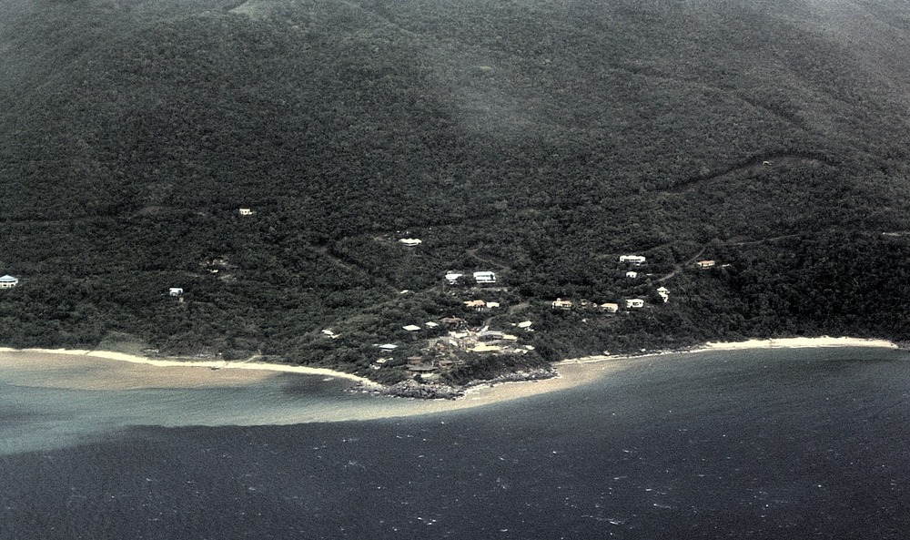
The organization who brought you this disaster for near-coastal waters of Nail Bay, Virgin Gorda, in November, 2003, are now bringing new wonders to the island. . . . this time with help of an Indian transnational corporation — note that the new road to Leverick Bay is not paved.

Dscf0054_nail_bay

Public road to Nail Bay paved and open to the public

VIRGIN GORDA, British Virgin Islands (October 4, 2009) – The Hon. Ralph T. O’Neal, OBE, Premier of the Virgin Islands (U.K.) officially opened the newly paved public road to Nail Bay just before sunset on Friday, October 2, 2009.

This opening ceremony was also attended by numerous people including Michael D. Riegels, Q.C., (director of Virgin Gorda Investment Company Limited which developed Nail Bay Resort), Mr. Douglas Riegels, President of Nail Bay Community Association Limited and Mr. Binny Sebastian, General Manager of Nail Bay Resort. 

“The opening of this newly concreted 22 feet wide public road to Nail Bay, beginning at the intersection at Pond Bay and the existing main Valley to the North Sound road, marks the completion of a major infrastructure project. This will make access to all the various properties along the northwestern shore of Virgin Gorda such as Pond Bay, Mango Bay, Mahoe Bay and Nail Bay much more comfortable for both residents and tourists alike who no longer have to navigate on unpaved dirt roads that washed away after each rain,” said Mr. Ajit Mathew George, Managing Director of Nail Bay Resort. 

He has been eagerly looking forward to this day since he first came to Nail Bay almost twenty-seven years ago in December 1982. Mr. George thanked the Premier for taking active leadership to complete this paving project of 12,400 feet (over 2.3 miles) of public road, which was initially started at the end of Nail Bay on December 9, 2006. He also expressed his gratitude to Daniel “Pops” Cline for his role as project manager and all the Virgin Gorda contractors who worked hard to complete the final phase of the project on a timely basis. 
 
The developers of Nail Bay Resort recently signed a Memorandum of Understanding (“MOU”) with the Taj Hotel Resorts and Palaces to develop in Virgin Gorda the first Taj Exotica Resort, Spa & Luxury Residences in the Caribbean, Central America and South America. Prior to the signing of this MOU, the Premier had publicly promised on July 15, 2009 at the VIP Reception for the 2009 Winemakers Dinners that the unpaved section of the public road to Nail Bay from Pond Bay would be paved before the end of this year. This VIP Reception was attended by Mr. Raymond Bickson, Managing Director and CEO, The Indian Hotels Company Limited and Uday Narain from the Taj Hotels Resorts and Palaces. 

Mr. George said that by completing the paving of this road three months before the end of this year, the Government of the Virgin Islands has once again demonstrated its commitment to attract a world class five star brand with an outstanding reputation for extraordinary service around the world including the Maldives, Malaysia, Australia, United Kingdom, Bhutan, Sri Lanka, Africa, the Middle East, United States of America and India such as the Taj Hotel Resorts and Palaces to the BVI  

Established in 1903, Taj Hotels Resorts and Palaces is one of Asia’s largest and finest group of hotels comprising 77 hotels, 7 authentic palaces, 6 private islands, 12 resorts and spas in over 52 destinations, 12 countries, 5 continents plus personal jets and luxury yachts. From world-renowned landmarks to modern business hotels, idyllic beach resorts to authentic Rajput palaces, each Taj hotel offers an unrivalled fusion of warm Indian hospitality, world-class service and modern luxury. 

Taj Hotels Resorts and Palaces is part of the Tata Group, India’s premier business house that owns among other things Tata Motors, Corus Steel and Jaguar Land Rover. The Tata Group, with over 100 companies, has over 350,000 employees and operates in more than 80 countries. For more information on Taj Hotels Resorts and Palaces, visit www.tajhotels.com 
 
Pursuant to the terms of the Development Agreement for Nail Bay Property that was executed by the Government of the Virgin Islands and the Developers of Nail Bay on December 16, 2006, the Government of the Virgin Islands approved, among other things, the construction and operation of a new five (5) star hotel of approximately one hundred (100) hotel units, plus additional hotel spa suites, hotel villas, townhouses and residential villas for sale with a luxury spa and related facilities including restaurants, bars, swimming pools, gift shops and boutiques at Nail Bay plus a private jetty and ten moorings.  

This historic 148 acre former sugar plantation below Gorda Peak with almost a mile of waterfront overlooking Sir Francis Drake Channel on the north western shore of Virgin Gorda has been in the process of being developed into a luxury villa resort with over 50 million dollars invested to date. Over the past three years, most of the secondary roads within Nail Bay have been paved in concrete after all the utilities were placed underground. Generators were installed to automatically provide stand-by electricity to all lots together with a state-of-the art internal water distribution system served by a desalination plant at Nail Bay. 

Rated #1 hotel in Spanish Town, Virgin Gorda by TripAdvisor.com and recommended by Frommers and The Best of the British Virgin Islands and named the best value in Virgin Gorda by Travel+Leisure Magazine, Nail Bay offers numerous distinctive villas, apartments and rooms with magical sunset views and three sun bleached, deserted, sandy beaches with great snorkeling. Nail Bay also offers modern conveniences such as ADSL internet service, satellite television and radio as well as DVD players and iPod stations and dining at the SUGARCANE restaurant.  For more information on Nail Bay, visit www.nailbay.com.  

Nail Bay was also the Founding Sponsor of the highly successful 2008 and 2009 Winemakers Dinners, which was organized by the BVI Charitable Fund.  

Posted in Uncategorized | Leave a comment

New Orleans: The Big Incompetent

Road Home Program Took a Wrong Turn in Mid-City Restorations

Sometimes it seems as though “Brownie” and “official” New Orleans deserved each other — why does Ray Nagin still have a job?

This from the excellent monthly newsletter of the National Hazards Center:

Road Home Program Took a Wrong Turn in Mid-City Restorations

A problematic program meant to help Louisianans rebuild after Hurricane Katrina doled out more than $3.2 million to refurbish houses that will soon be rubble, according to a recent article in the New Orleans Times-Picayune.

Louisiana’s Road Home program, now managed by the Louisiana Recovery Authority, has had no shortage of financial woes and missteps. The program has suffered management issues, budget shortfalls in the billions, and the faltering faith of the pubic since its inception in 2006.

The latest tumble, however, comes from a state plan to flatten 70 acres in New Orleans’ Mid-City for a hotly debated medical campus to replace the hurricane-damaged Charity Hospital and add a Veteran’s Administration hospital, according to the article. The same pot of federal housing funds that support the Road Home program would be used to buy out the freshly restored homes.

“That the state was strongly considering these sites was no secret to the public, but the final site selections for the hospitals had not been made,” Louisiana Recovery Authority Spokesperson Christina Stephens told the Times-Picayune. “We simply could not deny homeowners grants if we were not sure they were in the footprint of the new hospitals.”

Homeowners, it seems, did have some reason to hope that their neighborhood would eventually be spared. Opponents of the sprawling campus and historic preservationists aiming to save Charity and the Mid-City district have worked hard to keep the plan from coming to fruition. As recently as mid-November, Louisiana’s Commission on Streamlining Government recommended conducting an independent study of an alternate plan to retrofit Charity into a state-of-the-art hospital rather than rebuilding, according to another Times-Picayune article.
Despite a state budget shortage and an ongoing dispute with the Federal Emergency Management Agency on what the federal portion of replacing Charity will be, the state has begun buyout offers in the area, according to the Times-Picayune.

Meanwhile, the Road Home program has started to bounce back from some of its earlier setbacks, freeing up funds earlier this year for low-income grantees and recently making good on promises to help residentsinstall mitigation measures, thanks to some help from FEMA’s Hazard Mitigation Grant Program.

Still, those grants that were wasted could have offset rebuilding in other areas and will now cost the state even more if it moves ahead with the hospital campus, according to Stephens.

“The state will base its buyout offerings on current appraised home values, meaning that homeowners who did rebuild their homes likely will get a higher buyout amount,” she told the Times-Picayune.

Natural Hazards Center482 UCBBoulder, CO 80309-0482Contact Us: hazctr@colorado.edu | (303) 492-6818

A Center in the Institute of Behavioral Science

© Regents of the University of Colorado

Posted in Uncategorized | Tagged , , , | Leave a comment

COUNCILS FACE LEGAL DILEMMA OVER SEA LEVEL RISE

[From a friend’s blog in the Seychelles, based on an article in Australia . . guess that globalisation thing is working. . .

hmmm — so maybe we should tell planners at the State, County and City level that they are legally liable for permitting development that might be reasonably expected to be flooded within the reasonable life of the project . . .

COUNCILS FACE LEGAL DILEMMA OVER SEA LEVEL RISE

From: My Sunshine Coast

23 November 2009
COUNCILS FACE LEGAL DILEMMA OVER SEA LEVEL RISE

Australia’s coastal councils face the possibility of costly legal actions as a result of recent changes to projected sea level rise, according to the National Sea Change Taskforce.

The Taskforce, which represents non-metropolitan coastal councils in all states, is advising member councils they will need to take into account the revised sea level rise scenario of 1.1m, which was announced in a new government report on climate change released last week.

Alan Stokes, the executive director of the Taskforce, said the process of approving development applications in coastal areas at potential risk of inundation could be thrown into disarray by recent changes in projected sea level rise.

“Development applications that were approved a week ago based on a projected sea level rise of 0.8m in Victoria, or 0.9m in NSW could already be shown to be based on scientific projections that are now redundant, exposing the consent authority to potential legal liability,” he said.

“The nation’s coastal councils need a greater measure of legal protection in order to provide some certainty in deciding development applications in areas at risk of sea level rise.”

Mr Stokes said it was only last year that some states were basing planning decisions on a projected sea level rise of 0.3m or 0.38m. “The release of the Federal Government report Climate Change Risks to Australia’s Coasts last Saturday has changed all that,” he said.

“No consent authority in the nation can now argue they were unaware of a potential sea level rise of 1.1m by the year 2100. That now appears to have become the default scenario, with some local variation, which planners around Australia will need to take into account when considering any coastal development application.”

“This is a national issue affecting all coastal councils which could have significant impacts on property owners seeking to proceed with developments in areas at perceived risk. It is an issue that urgently requires clarification, as recommended in the report of the coastal Inquiry by the House of Representatives Standing Committee on Climate Change.”

A leading environmental lawyer supported the need for coastal councils to examine the nature and extent of potential climate change impacts very carefully when considering coastal development applications.

Andrew Beatty a partner specialising in environment law with the law firm Baker & McKenzie said there was no doubt that failure to consider climate change impacts when making coastal planning decisions leaves councils exposed to the risk of costly legal actions.

“These cases are complicated by the fact that climate change impacts on coastal land do not occur immediately or in predictable ways,” he said. “Each case will turn on its own facts.”
Posted by Rolph Payet

http://sealevelrise.blogspot.com/2009/12/councils-face-legal-dilemma-over-sea…

Posted in Uncategorized | Leave a comment

Major Sea Level Rise Prediction: 1.4 meter Antarctic Ice Melt by 2100

This report from the BBC at http://news.bbc.co.uk/2/hi/science/nature/8387137.stm

[Excerpt —>>

Major sea level rise likely as Antarctic ice melts
By Richard Black
Environment correspondent, BBC News website

999999_46831569_whalesafp466

The Southern Ocean is the world’s most important feeding ground for whales

Sea levels are likely to rise by about 1.4m (4ft 6in) globally by 2100 as polar ice melts, according to a major review of climate change in Antarctica.

Conducted by the Scientific Committee on Antarctic Research (SCAR), it says that warming seas are accelerating melting in the west of the continent.

Ozone loss has cooled the region, it says, shielding it from global warming.

Rising temperatures in the Antarctic Peninsula are making life suitable for invasive species on land and sea.

The report – Antarctic Climate Change and the Environment – was written using contributions from 100 leading scientists in various disciplines, and reviewed by a further 200.

see the entire article at http://news.bbc.co.uk/2/hi/science/nature/8387137.stm

Posted in Uncategorized | Leave a comment